
Excursions
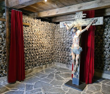


Beinhaus / Ossuary Leuk, Friedhofstrasse, Leuk, Switzerland
Beinhaus / Ossuary Leuk
In southern Switzerland, just where the French-speaking part of the Canton of Valais becomes the German-speaking Wallis, the town of Leuk holds a secret. That secret has nothing to do with the fact that the Onyx spy system has been installed on its territory. Even more arcane than intercepting communication between the living targets, the cryptic vibe spreads in the literal underworld of Leuk, among the dead. In the obscure basement of the Church of St. Stephan, 22,000 neatly displayed skulls form a wall of silence. Beinhaus Leuk is a charnel house with some tight-lipped householders hiding under the prayers’ feet for centuries.
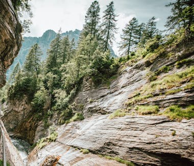

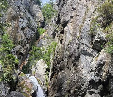
Dalaschlucht, Leukerbad, VS
Thermalquellen-Steg
The thermal springs within reach
Dramatic and poetic at the same time, the thermal springs walkway leads a few meters above the stream bed into the wild Dala Gorge.
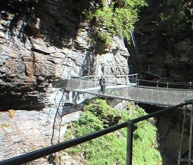
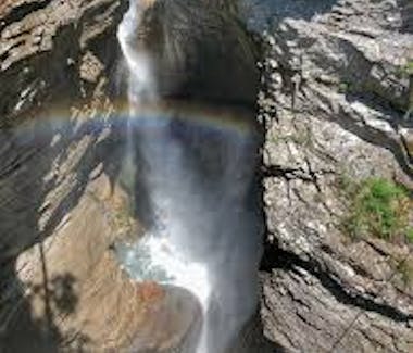
The thermal springs walkway is an impressive steel structure that runs through the Dala Gorge for around 600 meters. Several thermal springs emerge in the immediate vicinity of the stream bed. A small cable system can even be used to lift the warm thermal water directly from a spring. A suspended bridge leads further to the roaring natural spectacle. You can feel the power of the water up close at the 35-meter-high waterfall. A true refreshment in the summer.
At the end of the walkway, there are four options to continue the hike: to the waterfall viewpoint, to Lake Majing and the Weidstübli restaurant, to the Buljes restaurant, or to the Chesa Teretschen restaurant near the Dala Bridge, opposite the Al Ponte condominium in the upper town.

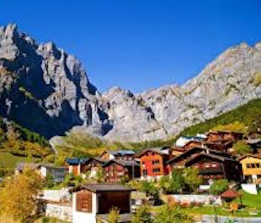
Guttet-Feschel, VS, Switzerland
The top mountain bike tours around Guttet-Feschel
The top mountain bike tours around Guttet-Feschel
The best MTB tours around Guttet-Feschel are not easy to find. But you have us. We have selected the most beautiful ones from our large collection of mountain bike tours around Guttet-Feschel and compiled them for your free use. Discover them right away on your MTB.
https://www.komoot.com/de-de/guide/29292/mountainbike-touren-rund-um-guttet-feschel
Guttet-Feschel, VS, Switzerland
The most beautiful hikes around Guttet-Feschel
The most beautiful hikes around Guttet-Feschel
When hiking, you can probably experience the landscape around Guttet-Feschel best. But first, you need the right hiking trails. And we can help with that: Choose one of the top hikes and discover the most beautiful hiking trails and hiking areas around Guttet-Feschel.
https://www.komoot.com/de-de/guide/29291/wandern-rund-um-guttet-feschel
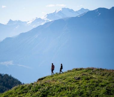
Leukerbad, VS, Switzerland
Summer in Leukerbad
Summer in Leukerbad
In the Leukerbad destination, mountain sports enthusiasts can fully enjoy the summer. Whether in the saddle, along hiking trails or on ropes in the rock:
Experience the wide range of mountain sports and relax in the evening in the warm thermal water.

Römerweg 2, 3954 Leukerbad, Switzerland
Winter in Leukerbad
Winter in Leukerbad
The nature in biting cold and the power of water in frozen form - Leukerbad in the garb of winter is fascinating. Immerse yourself and enjoy the adventure of snow.

Susten, Leuk, Switzerland
Rafting auf der Rhone
Rafting auf der Rhone
Der Rhone-Fluss ist insgesamt 807 km lang und mäandert durch das Rhônetal im Kanton Wallis. Er hat das höchste Wasserwolumen als Fluss in der Schweiz.
Es gibt zwei Flusswanderungen für Rafting-Fans mit unterschiedlichen Schwierigkeitsgraden.
Die erste Tour startet in Susten und führt etwa 9 km bis nach Sierre. Diese Tour ist für erfahrene Rafter geeignet. Denn die Wellen sind in der Regel nicht nur sehr hoch, sondern auch massiv. Die Route wird "Adventure Parcour" genannt.
Wenn Sie es etwas würdevoller mögen, können Sie die zweite Tour von Sierre nach Sion wählen. Das Wasser ist angenehm zum Fahren. Auf der 20 km langen Strecke haben Sie immer die Möglichkeit, kurz anzuhalten, zu schwimmen oder ein Picknick zu machen.
https://www.swissactivities.com/en-ch/rafting/#rafting-rhone

Gorges du Dailley, Salvan, Switzerland
Schluchtabenteuer in den Gorges du Dailley
Schluchtabenteuer in den Gorges du Dailley
Die Rundwanderung von Salvan nach Van d’en Bas führt durch die spektakulären Gorges du Dailley. Die Schlucht wird mit steilen Treppen und mit Stegen überwunden, die an senkrechten Felswänden angelegt sind. Es gibt überall Geländer, doch die Tiefblicke kosten zuweilen Mut.
Pyramides d’Euseigne, Sauterot, Hérémence, Switzerland
Erdpyramiden von Euseigne
Erdpyramiden von Euseigne
Euseigne liegt im Val d'Hérens, einem Seitental der Rhône, in der Nähe der weltweit höchsten Staumauer, der Grande Dixence. Die Erdpyramiden von Euseigne sind eine der bedeutendsten geologischen Sehenswürdigkeiten der Alpen und stehen unter Schutz.

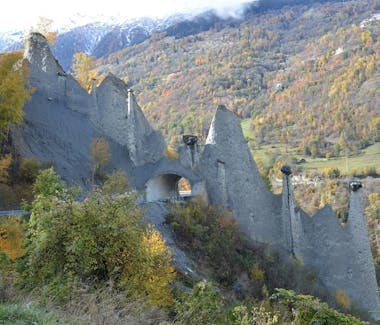
Naturpark Pfyn-Finges, Salgesch, Switzerland
Naturpark Pfyn-Finges
Naturpark Pfyn-Finges
Zwischen Sierre und Leuk im Kanton Wallis befindet sich das Schutzgebiet Pfynwald, welcher das Kernstück des Regionalen Naturparks Pfyn-Finges bildet. Einer der grössten zusammenhängenden Föhrenwälder der Alpen, bedeutendes Auenschutzgebiet mit einzigartig vielfältiger Fauna und Flora sowie ein Amphibienlaichgebiet von nationaler Bedeutung. Die Wanderung führt von Sierre via Pfynwald, Rosensee, L’Ermitage, Pfafforetsee, Pfyndenkmal, Illgraben zur spektakulären Bhutan Hängebrücke nach Leuk.
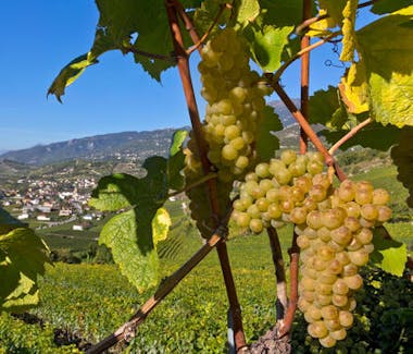
Salgesch, Salgesch, Switzerland
Das Weindorf der Schweiz
Weindorf der Schweiz
Die Gewächse aus der grössten Weinbaugemeinde Salgesch im Oberwallis sind bei den Weinkennern seit Jahrzehnten ein Begriff. Sortenvielfalt, Typizität, Mengenbeschränkung und die reichhaltigen Böden geben jeder einzelnen Traube die unverkennbaren Aromen und Inhaltsstoffe.

Martigny, Switzerland
Martigny
Martigny
Das inmitten von Rebbergen und Fruchtbäumen gelegene Martigny ist bekannt für seine Gastronomie, die in vielen hervorragenden Gasthäusern und Restaurants zelebriert wird. Unter der heissen Walliser Sonne wachsen in der Region Erdbeeren, Aprikosen, Trauben, Spargeln etc. Von den kulinarischen Vorzügen der Region liessen sich in der Vergangenheit bereits Persönlichkeiten wie Rousseau, Goethe, Stendhal oder Liszt verführen.
Martigny blickt auf eine zweitausendjährige Geschichte zurück: Keltische Stämme, die Römer und die Truppen Napoleons haben hier ihre Spuren hinterlassen. Heute kann in Martigny ein restauriertes Amphitheater bestaunt werden, aber auch römische Thermen, Tempel und Wohnquartiere. Später wurde Martigny erster Bischofssitz der Schweiz und überzeugt heute durch seine historischen Stadtteile La Bâtiaz und Vieux-Bourg mit zahlreichen sehenswerten kirchlichen und weltlichen Gebäuden.


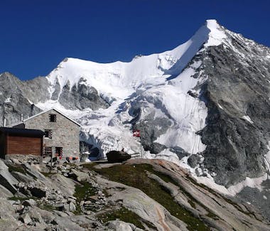
Mont Fort, Nendaz, Switzerland
Mont Fort
Mont Fort
Der Mont Fort befindet sich in der Nähe der Ferienorte Nendaz und Verbier im Schweizer Kanton Wallis, zwischen den Tälern Bagnes und Nendaz, nördlich der Rosablanche. Der Gipfel des Mont Fort hat eine Höhe von 3328 m; er ist der höchste Gipfel nördlich des Col de Louvie. Verwaltungstechnisch liegt der Mont Fort zwischen den Gemeinden Nendaz und Val de Bagnes.
Der Berg ist von mehreren Gletschern umgeben. Der größte von ihnen ist der Tortin-Gletscher auf der Nordwestseite; der zweitgrößte ist der Mont-Fort-Gletscher auf der Nordostseite. Östlich des Mont Fort befindet sich mit 3.135 m ein niedrigerer Gipfel, der „Petit Mont Fort“ genannt wird; der Petit-Mont-Fort-Gletscher liegt zwischen diesen beiden Gipfeln. Auf der Südseite des Berges gibt es keinen Gletscher. Ein kleiner See, der Lac du Petit-Mont-Fort, befindet sich an der Südflanke auf 2.644 m Höhe.
Der Gipfel des Mont Fort ist mit der Seilbahn von den Höhen von Nendaz oder Verbier aus erreichbar. Die Seilbahnen der beiden Täler laufen an einer Zwischenstation auf 2.894 m nördlich des Col des Gentianes zusammen; von dort aus erreicht die Seilbahn Mont-Fort eine Höhe von 3.308 Metern. Im Sommer 2022 wurde die in den Fels gehauene Treppe zum Gipfel durch eine breite Metalltreppe ersetzt mit einer großen Metallplattform rund um den Gipfel mit seinem Kreuz, das in der Mitte der Plattform verblieben ist. Dier Eröffnung der Aussichtsplattform erfolgte im Winter 2022/2023.
Der Mont Fort bildet zusammen mit dem Tortin-Gletscher den höchsten Punkt des Skigebiets der „4 Vallées “. Eine Skipiste führt wieder hinunter zum Col des Gentianes, von wo aus die Pisten nach Siviez (Nendaz) oder Verbier führen.

Weisshorngruppe, Randa, Switzerland
Weisshorngruppe
Die Weisshorngruppe
ist ein Bergmassiv in den Walliser Alpen. Sie liegt zwischen dem Mattertal im Osten und dem Zinaltal im Westen, an deren Nordflanke enden das Jungtal und das Turtmanntal. Die Weisshorngruppe ist nach dem Mont-Blanc-Massiv, dem Monte Rosa und der Mischabel das vierthöchste Gebirgsmassiv der Alpen. Ihr Hauptgipfel ist das Weisshorn mit 4505 m ü. M.


Schwarzhorn, Saas-Fee, Wallis, Switzerland
Schwarzhorn
Das Schwarzhorn
ist 4.322 m hoch und liegt im Walliser Grenzkamm südlich der Ludwigshöhe. Es zählt zur Monte-Rosa-Gruppe an der Grenze zu Italien und hat daher auch einen italienischen Namen, nämlich: Corno Nero. Er gilt als nicht sehr selbstständiger Gipfel, weist er doch eine Schartenhöhe von gerade einmal 50 Metern auf. Dennoch ragt der markante Felskopf merklich aus der Eismasse des Monte-Rosa-Massivs auf.
Und auch in puncto Formschönheit braucht sich das Schwarzhorn nicht zu verstecken. Die steil abfallende Südseite des Bergs besteht aus dunklem Gestein, im Osten bricht das Schwarzhorn – wie auch die Ludwigshöhe – ebenso steil zum Ghiacciaio delle Piode (Piode-Gletscher) ab. Und auch der Gipfelblick hat es in sich: Dufourspitze, Zumsteinspitze, Parrotspitze, Ludwigshöhe und Signalkuppe scheinen zum Greifen nahe.


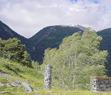
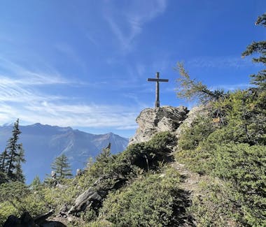
Wiler, Guttet-Feschel, VS, Switzerland
Lyrik-Weg
Ein unscheinbarer Weg führt von Wiler in den Rigge und lädt den Besucher ein, die beeindruckende Landschaft auf sanfte Weise zu erkunden. Mit musikalisch untermalten Gedichten und Texten werden die Sinne geschärft: innehalten, das Jetzt spüren, die Natur wahrnehmen. Gleichzeitig regt der Lyrik-Weg zum Nachdenken über die Zukunft an, zum Träumen über das, was kommen könnte, und zur Reflexion über den eigenen Beitrag dazu. Der Pfad wird durch natürliche, lokal gewonnene Materialien ergänzt und soll auf nachhaltige Weise inspirieren, entschleunigen und eine tiefgehende Verbindung zur Natur und sich selbst fördern. Der Lyrikweg ist ein Bestandteil des Kulturwegs Guttet-Feschel und wird jedes Jahr durch neue Audioproduktionen bereichert.

Zermatt, Switzerland
Zermatt
Zermatt - das Bergdorf der Rekorde
Zermatt liegt am Fusse der höchsten Berge des gesamten Alpenbogens. Mit Matterhorn, Weisshorn, Monte Rosa. Ein einziger Besuch im Matterhorndorf reicht nicht, um alle Attraktionen und Rekorde zu begreifen.
Ein Ausflug auf den Gornergrat ist ein Must. Von hier aus sind 29 Viertausender zu bestaunen - ein Rekord im Alpenraum. Im Bergsteigerfriedhof bei der Kirche ist zu sehen, dass Berge dem Menschen gegenüber hart sein können. Wer in die facettenreiche Welt von Zermatt eintaucht, wird in den Bann der eindrücklichsten Bergwelt gezogen.

Crans-Montana, Switzerland
Summer and Winter in Crans-Montana
Summer in Crans-Montana
Immerse yourself in the great outdoors
Crans-Montana is the perfect destination for amazing summer breaks in the mountains. Take a dip in one of our lakes and unwind on the beach while enjoying one of the many water sports activities on offer for people of all ages.
Hiking fans will be truly spoiled by the stunning scenery along the vast network of trails, from vineyards and forests to bisse irrigation canals and alpine peaks. Cyclists will be just as thrilled with the variety of road cycling and mountain bike tours, as well as three downhill tracks.
https://www.crans-montana.ch/en/summer/
Crans-Montana in the Winter
Ski & Snowboard
At an altitude ranging from 1,500 to 3,000 metres, the Crans-Montana ski area offers breathtaking views from its 140 kilometres of completely south-facing marked pistes. With pistes suitable for all levels, which stretch from the mountaintops which tower above the Plaine Morte Glacier to the golf course on the 'Haut-Plateau' below, via the snowpark, the ski area is varied and promises unforgettable days skiing.
https://www.crans-montana.ch/en/activities_/ski/
Crans-Montana, Switzerland
Crans-Montana Ski & Snowboard
Crans-Montana Ski & Snowboard
At an altitude ranging from 1,500 to 3,000 metres, the Crans-Montana ski area offers breathtaking views from its 140 kilometres of completely south-facing marked pistes. With pistes suitable for all levels, which stretch from the mountaintops which tower above the Plaine Morte Glacier to the golf course on the 'Haut-Plateau' below, via the snowpark, the ski area is varied and promises unforgettable days skiing.
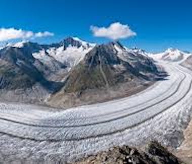
Aletschgletscher, Fieschertal, Switzerland
Aletschgletscher
The Great Aletsch Glacier
is a sight of archaic beauty. High up, at the viewpoints Hohfluh, Moosfluh, Bettmerhorn and Eggishorn, the size and uniqueness of the Great Aletsch Glacier becomes most impressive. The fascination of the huge ice stream, which extends over a length of 20 km from its catchment area in the Jungfrau region (4000 m) down to the Massa Gorge situated about 2500 m lower, is irresistible.
https://www.aletscharena.ch/weltnaturerbe/grosser-aletschgletscher
Domodossola, Province of Verbano-Cusio-Ossola, Italy
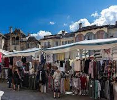
Markt in Domodossola
Market in Domodossola
A popular market, great excursion opportunities, delicious pasta, sweet desserts and delicious wine - thanks to the 2-hour schedule, the Dolce Vita is even closer to German-speaking Switzerland. Domodossola, especially on Saturdays, attracts many excursionists to its well-known and popular market.
The strengths of the Domodossola market are the leather goods and the typical products from the Ossola valleys. An incredible variety of cheeses from all over Italy, all kinds of meat, fruits and vegetables depending on the season. The range of clothing extends from evening dresses to pajamas, underwear, shoes and socks. Bags, jackets, belts and hats made of leather are available in abundance. DIY enthusiasts and crafters can also find useful items here.
https://www.bls.ch/de/freizeit-und-ferien/ausfluege/bls-loetschberger-markt-domodossola

Zoo Safari - Pombia (no), V, Pombia, Province of Novara, Italy
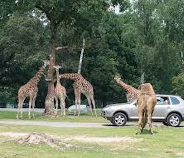
Safari Park Pombia
Safari Park Pombia
Born in 1976 in Pombia, at the gates of Novara on Lake Maggiore, Safari Park was taken over in 1998 by Orfeo Triberti. Since then, a long path has been taken to make the 450,000 square meters of space, surrounded by woods, worthy of the highest management and protection standards for the over 400 animal species present.
Thanks to the commitment, professionalism and incessant work of highly qualified personnel, specialized veterinarians, researchers and keepers, the animals benefit from a healthy environment, created for their well-being and protection.
A Park designed to know, love and be moved, which, in addition to the Safari area where the animals live in protected freedom, offers many other activities that develop through experiential and educational paths among the biodiversities, to learn while having fun.


Borromäische Inseln, Stresa, Province of Verbano-Cusio-Ossola, Italy
Borromean Islands
The Borromean Islands
are a group of five freshwater islands in the Italian part of Lake Maggiore. They are located in the Gulf of Verbania, between Verbania in the north and Stresa in the south. They have a total area of 18 hectares.
Their name derives from the Borromeo family, who have owned the islands since the 12th century.
Isola Bella, named after Isabella, the Countess Borromeo, was originally a predominantly barren rock. Between 1650 and 1671, Vitaliano VI Borromeo built an attractive summer palace on the island. He had large amounts of soil brought to the island to create a pyramidal system of ten terraces for the garden. The unfinished building houses paintings by Lombard artists and Flemish tapestries. From a magnificent staircase, one reaches the Medal Room, named after the round paintings on the ceiling. This is followed by the Music Room, a conference room, and the magnificent Napoleonic Room, where Napoleon spent a night. The large banquet hall is also worth seeing. The "grottoes" of the castle are also famous for the many stones and the displayed corals.